Aviation Merchandise

Digital Sectional App Subscription
- Item Number
- 185
- Estimated Value
- 350 USD
- Sold
- 220 USD to shilohsmith
- Number of Bids
- 10 - Bid History
Item Description
This item is for a 5-year unlimited subscription to Digital Sectional EFB.
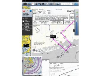
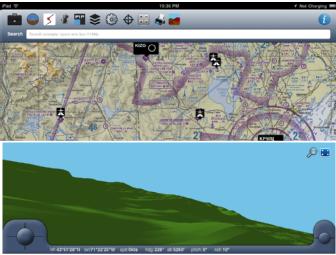
Digital Sectional is an iPad/iPhone app that allows you to download and view any of the current U.S. aviation charts (IFR, VFR, TAC, WAC, Helicopter, etc). A terrain database is also available that will overlay a color-coded layer on the map based on your current proximity to the ground. Additionally, the latest A/F directory and geo-referenced plates can be installed. A head's-up-display is also included. Flight plans can be plotted either manually by tapping on the map or entered in a standard style of “<departing airport> <waypoint1> <waypoint2> <waypoint x> <destination airport> <speed>” e.g.: “BOS ENE KIFFI PWM 114kts”. The map with the route on it can be printed.
Charts Available:
• IFR Atlantic and Trans-Atlantic to Europe
• IFR High and Low
• Helicopter Route Charts
• VFR Sectionals
• WAC Charts
• TAC Charts
Features:
• Controlled airspace shown on the map and can dynamically adjust based on your altitude and position
• Geo-referenced approach plates even on the map! - Please check out our website for more info about this
• Print the map view
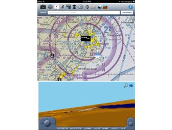
• Search for airports from the map
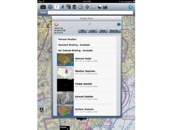
• METAR and TAF information with custom map markers
• Navigational Aids on Map
• Simple E6B
• Ability to draw a flight route on the map (no filing yet)
• Picture-in-Picture allows a secondary, smaller map for additional situational awareness
• Route recording and playback. You can even share your routes by copying the files through iTunes
• Terrain awareness map overlay - Color coded situational awareness
• IFR Charts can be overlaid transparently or opaquely for a unique experience
• Airport database with info and frequencies
• Digital Airport/Facility Directories (Green Books - Printable)
• Digital FAA Terminal Procedures (Printable)
• Obstacle database for all published obstacles 400' AGL and higher
• Very detailed basemaps from Mapbox
• Graphical HUD to display Ground Track, Ground Speed, Altitude and Vertical Speed
• Resumable downloads
Donated By:

AOPA Foundation stores data...
Your support matters, so AOPA Foundation would like to use your information to keep in touch about things that may matter to you. If you choose to hear from AOPA Foundation, we may contact you in the future about our ongoing efforts.
Your privacy is important to us, so AOPA Foundation will keep your personal data secure and AOPA Foundation will not use it for marketing communications which you have not agreed to receive. At any time, you may withdraw consent by emailing Privacy@frontstream.com or by contacting our Privacy Officer. Please see our Privacy Policy found here PrivacyPolicy.