Consulting Services

Aerial Mapping of One (1) 18-Hole Golf Course Using Near-InfraRed & Visible Light
- Item Number
- 186
- Estimated Value
- 2700 USD
- Opening Bid
- 675 USD
Item Description
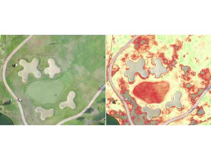
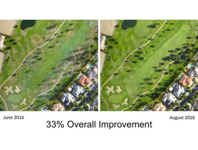
Aerial Mapping, by 3Rings Media's FAA-Certified drone pilots, leveraging Near-InfraRed & Visible light, pinpoints threats to Turf Health, allowing Golf Course Superintendents, and their team, to act before these threats become widespread and spot-treat areas displaying the highest levels of stressed and browning turf. Being able to spot-treat vs. blanket-treat an entire golf course, significantly reduces the cost of labor & materials, is better for the environment, improves the level of playability, and is helpful in maintaining healthy relations with nearby residents. For more information, including two case studies, view our video at http://bit.ly/2o9lEUy.
Aerial Mapping is available ONLY in Connecticut, New Jersey, the following counties in New York, and according to local FAA regulations:
- Albany
- Bronx
- Columbia
- Delaware
- Dutchess
- Greene
- Kings
- Nassau
- New York
- Orange
- Putnam
- Queens
- Rensselaer
- Richmond
- Rockland
- Schenectady
- Schoharie
- Suffolk
- Sullivan
- Ulster
- Westchester
Service may not be be available within five miles of an international airport.
Proceeds benefit the Environmental Institute for Golf.
Donated By:

GCSAA Foundation stores data...
Your support matters, so GCSAA Foundation would like to use your information to keep in touch about things that may matter to you. If you choose to hear from GCSAA Foundation, we may contact you in the future about our ongoing efforts.
Your privacy is important to us, so GCSAA Foundation will keep your personal data secure and GCSAA Foundation will not use it for marketing communications which you have not agreed to receive. At any time, you may withdraw consent by emailing Privacy@frontstream.com or by contacting our Privacy Officer. Please see our Privacy Policy found here PrivacyPolicy.